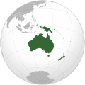
Failu:Oceania (orthographic projection).svg

Tämän PNG-ezikaččelun suurus SVG-tiijostoh niškoi: 541 × 541 pikselii. muut rezol'uciet: 240 × 240 pikselii | 480 × 480 pikselii | 768 × 768 pikselii | 1 024 × 1 024 pikselii | 2 048 × 2 048 pikselii.
Alguperäine tiijosto (SVG-failu, nominualizesti 541 × 541 pikselii, tiijoston suurus: 63 KiB)
Tiijoston histourii
Painalda päivymiäriä/aigua kaččuo, mittuine tiijosto oli silloi.
| Päivymiäry/aigu | Pieni kuva | Suurus | Käyttäi | Huomavus | |
|---|---|---|---|---|---|
| nygöine | 6. Tuhukuuta 2023 kello 21.54 |  | 541 × 541 (63 KiB) | Golden Mage | A change to the map of Asia will first face debate from others. Hence, a change to the commonly accepted map of Oceania cannot be made without a wider consensus. |
| 6. Tuhukuuta 2023 kello 09.33 |  | 541 × 541 (108 KiB) | Kwamikagami | rv: then perhaps we need to change the Asia map to match. This is as defined in WP. | |
| 5. Tuhukuuta 2023 kello 21.19 |  | 541 × 541 (63 KiB) | Golden Mage | Reverted to the map that displays the more accepted definition of Oceania's boundaries. Widely accepted geopolitical definitions take precedence over mere geographical ones. The map of the Wikipedia page for Asia already includes the Maluku Islands. | |
| 5. Tuhukuuta 2023 kello 08.01 |  | 541 × 541 (108 KiB) | Treetoes023 | Reverted to version as of 06:27, 24 December 2022 (UTC) | |
| 5. Tuhukuuta 2023 kello 08.00 |  | 541 × 541 (63 KiB) | Treetoes023 | Reverted to version as of 13:25, 31 December 2022 (UTC) | |
| 5. Tuhukuuta 2023 kello 07.55 |  | 541 × 541 (108 KiB) | Treetoes023 | Reverted to version as of 00:31, 4 December 2022 (UTC) | |
| 31. Talvikuuta 2022 kello 16.25 |  | 541 × 541 (63 KiB) | Golden Mage | Reverted to the map that displays the more accepted definition of Oceania's boundaries. Widely accepted geopolitical definitions take precedence over mere geographical ones. | |
| 24. Talvikuuta 2022 kello 09.27 |  | 541 × 541 (108 KiB) | Kwamikagami | Reverted to version as of 00:31, 4 December 2022 (UTC) definition per WP-en | |
| 22. Talvikuuta 2022 kello 09.13 |  | 541 × 541 (63 KiB) | Golden Mage | Reverted to the map that displays the more accepted definition of Oceania's boundaries. | |
| 4. Talvikuuta 2022 kello 03.31 |  | 541 × 541 (108 KiB) | Kwamikagami | the Weber line divides Oceanic from Asian Wallacea |
Tiijoston käyttö
Tämä sivu käyttäy tädä tiijostuo:
Tiijoston globualline käyttö
Nämmä jällesolijat wikit käytetäh tädä tiijostuo:
- Käyttö ab.wikipedia.org kohtas
- Käyttö ady.wikipedia.org kohtas
- Käyttö af.wikipedia.org kohtas
- Afrika
- Asië
- Europa
- Kiribati
- Noord-Amerika
- Suid-Amerika
- Vanuatu
- Guam
- Nieu-Seeland
- Sjabloon:Kontinente
- Australië
- Nauru
- Wellington, Nieu-Seeland
- Hoofstad
- Lys van hoofstede
- Sjabloon:Lande van Oseanië
- Honolulu
- Antarktika
- Gondwana
- Eurasië
- Laurasië
- Kategorie:Lande in Oseanië
- Lys van lande
- Fidji
- Canberra
- Hawaii
- Lys van nasionale leuses
- Clipperton
- Oseanië
- Norfolkeiland
- Amerikas
- Tonga
- Tuvalu
- Sjabloon:Hoofstede in Oseanië
- Palau
- Australië (kontinent)
- Afrika-Eurasië
- Samoa
- Marshalleilande
- Salomonseilande
- Papoea-Nieu-Guinee
- Gefedereerde State van Mikronesië
- Nukuʻalofa
- Port Moresby
- Apia
- Funafuti
- Honiara
- Majuro
Kačo ližiä tämän tiijoston globuallizes käytös.

